0 ratings

Item #:
104649306
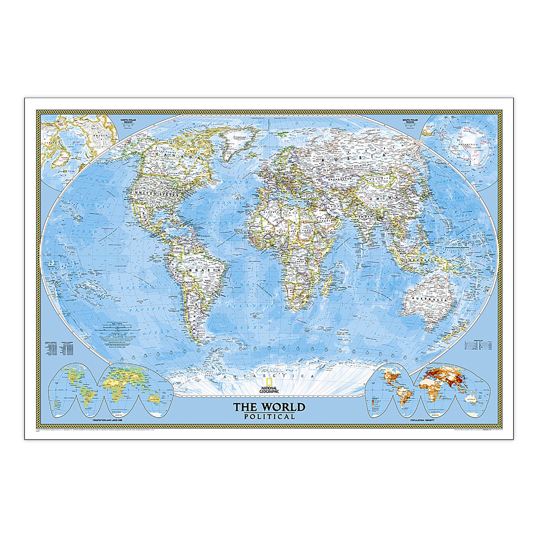
National Geographic World Classic Map, Laminated, 43.5 x 30.5
Item #:
104649306
XCD 155
Price Details
Excluding Shipping & Custom charges ( Shipping and custom charges will be calculated on checkout )
*All items will import from US
0 ratings
Write a review
In stock
QTY:
Order now and get it around Wednesday, July 08
Secured transaction
Ubuy works hard to protect your security and privacy. Our advanced payment security system ensures confidentiality by encrypting your information during transmission using AES (Advanced Encryption Standards) and SSL (Secure Socket Layer) protocols. Your payment details are 100% secure as we do not share your payment details with third party sellers.
Our Top Logistics Partners
National Geographic's World Wall Map is the authoritative map of the world by which other reference maps are measured.
Fast
Shipping
Free
Return*
Secure Packaging
100% Original Products
PCI DSS Compliance

ISO 27001 Certified
Note: Step Down Voltage Transformer required for using electronics products of US store (110-120). Recommended power converters Buy Now.


What Stands Out
High-Quality Lamination
This map's durable, laminated finish ensures longevity and resistance to wear, making it ideal for frequent use in schools, offices, or as a decorative piece.
Detailed World Coverage
Featuring intricate details of countries, capitals, and major cities, this map offers an informative and visually appealing way to enhance geographical knowledge.
Large Format Size
Measuring 43.5 x 30.5 inches, this map provides a spacious view perfect for wall displays, education, or as an engaging conversational piece in homes and offices.
Product Details
Who Should Buy?

-
Educational Use
Ideal for classrooms to enhance geography lessons with detailed world features and clear landmarks.
-
Travel Planning
Perfect for travelers and adventurers seeking a durable map for planning routes and exploring new destinations.
-
Home Decor
An attractive addition to any room, showcasing a beautifully colored world map that appeals to geography enthusiasts.

-
Small Spaces
Too large for limited wall space, making it unsuitable for users with compact rooms or apartments.
-
Digital Users
Not suitable for tech-savvy individuals who prefer maps available on their devices or GPS applications.
-
Frequent Updates
Not ideal for those needing frequently updated geographical information, as this map may not reflect the latest changes.
Product Description
National Geographic World Classic Map, Laminated, 43.5 x 30.5
Have any Query? Chat with us
Customer Questions & Answers
-
Question:
What is the size of the National Geographic World Wall Map?
Answer: The map measures 43.5 x 30.5 inches. -
Question:
Can the laminated map be framed easily?
Answer: Yes, the laminated map can be framed without the need for glass, making framing lighter and less expensive. -
Question:
What makes this map different from other wall maps?
Answer: This map is meticulously researched and is considered the authoritative reference for accuracy and detail.
National Geographic Editorial Review
No editorial reviews found
Customer Reviews & Ratings
1 customers ratings
-
5 Star
100%
-
4 Star
0%
-
3 Star
0%
-
2 Star
0%
-
1 Star
0%
Review this product
Share your thoughts with other customers
Product Price History
Important information
- Limitations : For products shipped internationally, please note that any manufacturer warranty may not be valid; manufacturer service options may not be available; product manuals, instructions, and safety warnings may not be in destination country languages; the products (and accompanying materials) may not be designed in accordance with destination country standards, specifications, and labeling requirements; and the products may not conform to destination country voltage and other electrical standards (requiring use of an adapter or converter if appropriate). The recipient is responsible for assuring that the product can be lawfully imported to the destination country. When ordering from Ubuy or its affiliates, the recipient is the importer of record and must comply with all laws and regulations of the destination country.
- Not all the products listed on Ubuy are for sale, as Ubuy is a global search engine. Products are subject to export/trade regulations.
XCD 155
Order now and get it around Wednesday, July 08
This item is not restrict in my country.(Please click on above link if this item is not restrict in your country, So our team will review and allow.)
QTY:
Secured transaction
Ubuy works hard to protect your security and privacy. Our advanced payment security system ensures confidentiality by encrypting your information during transmission using AES (Advanced Encryption Standards) and SSL (Secure Socket Layer) protocols. Your payment details are 100% secure as we do not share your payment details with third party sellers.
Our Top Logistics Partners
Fastest cross-border delivery
Features & Benefits
- Expertly researched using authoritative sources like the U.N. and U.S. Board on Geographic Names.
- Features a vibrant, easy-to-read color palette with distinct borders and labeled mountain ranges.
- Durable 1.6 mil laminate protects against humidity and allows for easy framing without glass.
- Includes accurate international boundaries, cities, and thousands of place names for legibility.
- Utilizes the Winkel Tripel projection to minimize distortions in geographical representation.
- Corner inset maps provide additional details on vegetation, land use, and population density.